The proposed Atlin Hydro Expansion Project would impact water levels at Surprise Lake and the flow of water on Pine Creek. A detailed description of these changes can be found on the page “Water Levels & Flows.”
Assessments by qualified professionals predict minimal impact to fish and wildlife as a result of these changing water levels and flows. The following describes the results of these assessments, as well as the Project’s mitigation strategies.
Surprise Lake
Birds
Field studies and assessments undertaken by qualified professionals identified minimal impacts to birds during the birds’ critical life stages. Shore-nesting birds typically complete nesting earlier than other species. While the lower lake level of the proposed Project may encourage birds to nest lower on the shoreline, the high-water level of the proposed Project is reached later in the season, giving the birds more time to complete this critical life stage. In other words, the delay in high-water level reduces the potential that nests will be flooded. Further, shore-nesting birds are adapted to fluctuations in water levels and are expected to adapt to the increased storage range.
Other possible impacts may occur due to changes in the availability and nature of various bird habitat, including wetlands. However, the relatively small area of inundation and limited change in storage range, as well as the availability of surrounding habitat means that effects to bird populations on Surprise Lake would be negligible, though some level of displacement may occur. THEL would monitor for impacts to birds and develop adaptive management measures.
Shoreline, beaches and wetlands
With changes to water levels, erosion would increase for a period of time, as well as some tree kill. Dead trees may be removed in winter, if deemed necessary. However, dead trees can provide nesting opportunities for birds, so risk factors, aesthetics, and potential wildlife benefits would be considered prior to removal. (Areas of higher use, such as the boat ramp, would be monitored, and mitigation employed to ensure the integrity and safety of these structures.)
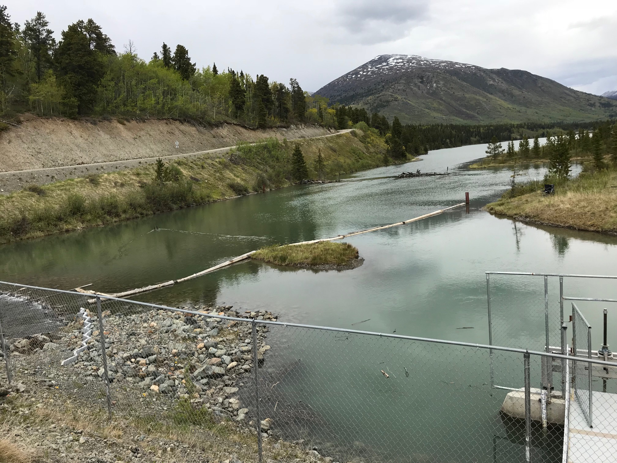
Several wetland areas would be inundated from mid-July onward. The boundaries and type of wetland are likely to change. For example, shrubbier wetlands may convert to those with more grasses and sedges. While the extent and magnitude of these changes are also expected to be minimal, THEL would monitor the changes to beaches and wetlands, and erosion more generally.
There are also several sandy beaches on Surprise Lake, including barrier beaches (such as Hemlock Creek Beach and Pine/Cup Beach) and the lagoons these beaches create. These beach formations would remain largely intact in the long term. Continued erosion and deposition (laying down of sediment – such as pebbles, sand etc. – by wind and flowing water) are predicted to continue to build and add to these landforms. Inundation would flood the lagoons and shrink the size of the beaches seasonally from mid-July onward. Over time, however, these beaches would likely grow and expand with continued erosion and deposition.
Wildlife
There would be minimal impacts to wildlife, such as moose and caribou, due to the small increase in water level and inundation. Movements of other wildlife, such as sheep, may be most affected at Pine/Cup Creek in the fall due to the increased level of average high water. This new level could move any existing crossing points along the beach or lagoon a short distance up the valley. Currently, THEL is monitoring wildlife movements across this area in cooperation with TRTFN Lands Department, via the use of wildlife game cameras.
Fish and fish habitat
Grayling are the primary species of interest in Surprise Lake, and the effect on grayling due to changes to water levels is expected to be neutral. Impacts to spawning habitat appear to be negligible, while there may be potential benefits to the increased availability of shallow nearshore water, which is used for rearing. The availability of this habitat may be a factor limiting the size of the grayling population in Surprise Lake, and this habitat would increase with inundation of some low-lying areas.
In terms of spawning habitat, the anticipated changes resulting from lower lake levels (compared to historic levels) is not expected to impact grayling productivity nor to result in a reduction of usable spawning habitat. There are no barriers to spawning channels created by low-water levels. Because grayling spawn during lower water from May to mid-June, existing channels would not be inundated at this time of year. Grayling are adaptable to a variety of spawning habitat conditions, so they are expected to be resilient to water-level changes in their spawning habitat. Nonetheless, THEL proposes to monitor grayling spawning during and after construction and to adapt the reservoir management strategy, if required.
Pine Creek
Fish
The most important reaches on Pine Creek in terms of their fisheries value are Upper Pine Creek Reach and, to a lesser extent, the Upper Bypass Reach. Grayling migrate between Spring Creek, a tributary in Upper Pine Creek, and Surprise Lake. With the proposed Project, small pools and other fish habitat would be maintained or re-created.
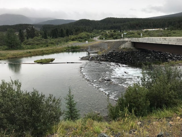
There is currently a fishway (a structure to enable fish to pass around a weir/dam, also called a fish ladder), which would be upgraded if required, to maintain fish passage between Pine Creek and Surprise Lake. Flows in both the Upper Pine Creek and Upper Bypass reaches would remain relatively high to maintain flows to the existing headpond, so fish passage between these reaches would be maintained, and impacts to habitat would be minimal. To sum up, biologists have determined that the productive capacity of these reaches for fisheries would be maintained.
The Middle Bypass Reach contains two barriers that prevent fish passage up Pine Creek from Atlin Lake: natural barrier of Pine Creek Falls, and the constructed dam at the existing headpond.
In the Lower Bypass Reach, the Lower Falls (a small cascade in a canyon visible from Pine Creek Trail), approximately 2.5 km upstream of Atlin Lake, also prevents fish from Atlin Lake from moving very far up the Creek. This means that fish found in the reaches between the two falls are those that have been swept downstream. For the fish that do enter Pine Creek from Atlin Lake, the lower year-round flows of 0.5 m3/sec to 0.8 m3/sec may discourage some use. However, the proposed tailrace from the lower powerhouse will create new habitat. This tailrace, located next to the creek, would be a large, slow-moving channel that rises and falls with the lake. The tailrace would incorporate fish habitat features into its construction, such as boulders and pools, and vegetation.
Although the fish population is not expected to be negatively impacted, fish habitat would be reduced by barriers to passage from the new weirs on Pine Creek, and the change in wetted width.
This means that habitat compensation measures would be required under a fisheries authorization. For this Project, TRTFN requested that we develop compensation on the lower end of Otter Creek rather than Pine Creek. THEL will be proposing to develop spawning habitat in lower Otter Creek near its outflow at Surprise Lake, as part of a larger TRT-led restoration project.